
Climate risk, resilience, and REITs: New Orleans
Part 2 of a series of blogs on what REITs should consider when selecting cities to invest in.
Cities across the US are realizing the short- and long-term negative impacts of climate change on their residents, infrastructure, and budgets. As a result, cities are investing in new infrastructure, implementing building codes, and testing policies designed to minimize climate risks. Policies implemented by cities to mitigate the impacts of climate change will have positive and negative impacts on the real estate investment trusts (REITs). In part one of this series we explored the positive and negative implications for REITs of policies enacted by San Francisco to mitigate the impacts of rising sea levels. In this blog we explore the measures that the State of Louisiana and the City of New Orleans are taking to mitigate the impacts of flooding and how they impact the financials for REITs with assets located in the city.
New Orleans faces a significant climate change driven flood risk owing to multiple sources of flooding i.e. Mississippi River, hurricane storm surge, sea level rise in the Gulf of Mexico, and extreme precipitation. However, over the past 15 years the City of New Orleans together with the state of Louisiana and the U.S. Army Corps of Engineers (USACE) have invested a significant amount of money in gray as well as green infrastructure, and plan to invest even more in the decades to come, thereby reducing the risk somewhat. REITs should build multiple scenarios and assess the impact of flooding on their assets and operations, invest in on-site urban greening such that it derives the maximum benefit from existing gray infrastructure, and support the State of Louisiana with its adaptation measures.
New Orleans faces three distinct sources of flood risk; with changing climate they might start reinforcing each other

Bonnet Carre Spillway, July 2019 Source: NOLA.com
The Mississippi river meets the Gulf of Mexico about 100 miles downstream of New Orleans and drains 40% of the water in the United States into the Gulf. Flooding due to high water volume in the Mississippi has been a known source of risk since the Great Mississippi Flood of 1927, after which an extensive network of levees was installed and operated by USACE under the Flood Control Act of 1928. This system of levees, spillways and pumping stations has worked well and avoided any Mississippi flooding driven damages to the City of New Orleans. However recent increases in spring flooding have led to the opening of the Bonnet-Carre spillway for a record 123 days, leading to large freshwater channeling into Lake Pontchartrain leading to toxic algae blooms, with negative impacts on the fishing industry.
The second risk is hurricane and tropical storm driven storm surges that push ocean water onshore. Climate change driven sea level rise increases the intensity of these events. Sea level rise also increases land erosion thereby removing frictional resistance to the surge. After Hurricane Katrina in 2005, the U.S. Army Corps of Engineers undertook an extensive effort to upgrade the flood protection system designed to guard against coastal storm surge. This work was completed in May 2018 at a cost of $14.5 Billion and now consists of 200 km of levees, flood-walls and pumping stations as shown below.

1. Lake Borgne Surge Barrier. 2. Bayou Bienvenue Sector Gate 3. Bayou Dupre Sector Gates 4. Seabrook Floodgate Complex. 5. Caernarvon Sector Gate 6. Levees, Floodwalls and Floodgates. 7. Mississippi River and Tributaries Levee System. 8. Permanent Canal Closures and Pumps. Source: U.S. Army Corps of Engineers
The third risk is on-land precipitation in and around New Orleans. For example, in the lead-up to Hurricane Barry in 2019, New Orleans received 4 to 8 inches of rain, flooding streets, cars, and buildings.
According to Prof. Alex Kolker at Louisiana Universities Marine Consortium, these three risks have largely stayed independent of each other, as spring flooding in the Mississippi and hurricane season are typically set apart by a few months. However with changing climate, spring flooding may extend later into the year and hurricane season may begin earlier in summer, thereby increasing the possibility of compounding risks. Indeed, all three risks coincided in 2019 when the Lower Mississippi River was above flood stage from January to August, and Hurricane Barry arrived in July with storm surge and extreme precipitation. Flooding in the Mississippi River basin in 2019 caused at least 12 deaths and economic damages exceeding $20 Billion.
Actions by city of New Orleans, State of Louisiana and U.S. Army Corps of Engineers will all have a critical bearing on the flood risk
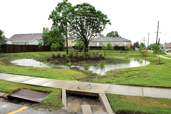
NORA Rain Garden in Filmore, Source: City of New Orleans
Rainfall-driven flooding is currently mitigated by a system of pipes, pumps, and canals that transport water from city streets into Lake Pontchartrain. According to Prof. Kolker, this system is designed to handle 1 inch of rain in the first hour and 0.5 inches of rain thereafter. This capacity has, at times, been reduced due to equipment malfunctions or outages, and obstruction to the flow of water in the system. The City of New Orleans has taken a number of steps to encourage urban greening and increasing permeable surfaces throughout the city. Examples of such initiatives include a resilience retrofit program that tries to get 20 year term PACE funding for households and businesses investing in rain gardens and home elevations. In addition, the city is pursuing FEMA Hazard Mitigation and National Disaster competition funding to fund upgrades of the stormwater management system. The new zoning ordinance requires runoff management during and after construction through measures such as bioswales and permeable pavement.
Although the initiative from the City of New Orleans in mitigating the rainfall driven flood risk is likely to be effective, it alone will not be sufficient. Much of the risk will come from how the new flood control system completed by USACE in 2018 will hold up. These levees are part of the Hurricane and Storm Surge Risk Reduction System, and are generally separate from the pumps that pump out rainwater. A recent filing in June 2019 by USACE is not particularly confidence enhancing. The filing states that the system originally rated to enhance protection against a 1:100 year event with waves and 1:500 year event without waves, will fail to do so as early as 2023 due to sinking land and levees. Subsidence in coastal Louisiana is due to the pumping of water that lowers the water table, but also due to oil and gas drilling, and reduction in wetlands due to the lack of sedimentation from holding the flow of Mississippi upstream.

Source: Louisiana Coastal Master Plan, Completed, Underway and Funded Projects.
The State of Louisiana has undertaken an ambitious master coastal plan with gray and green infrastructure projects. A number of these have already been completed, are underway or funded. This plan is slated to cost $50 Billion over the next 50 years. The state has already secured approximately $7 Billion from the Deepwater Horizon settlement with British Petroleum (BP) that it intends to use for this purpose and additionally has secured money from FEMA Hazard Mitigation.
Although the types of gray and green infrastructure are myriad, the two biggest chunks are $19 Billion for structural measures such as levee armoring and upgrade and $17 Billion for marsh and wetland restoration. Marsh and wetland restoration includes a variety of strategies including sedimentation diversion from the Mississippi, directly building marshes with dredge spoil, and planting native species. For example, David Pond project diverts fresh water, with its accompanying nutrients and sediments, from the Mississippi River into the Barataria Basin, reducing saltwater intrusion and establishing favorable salinity conditions in the area, thus combating land loss. A picture of David Pond Diversion is shown below.

David Pond Diversion. Source: Prof. Alex Kolker, Southwings.
How REIT’s Should Respond
What does this mean for REITs with existing and/or planned properties in New Orleans and what should they do?
Build multiple scenarios for flood risk including some with two or three source risks combined. REITs should build 3-5 scenarios based on critical uncertainties around the risk of flooding. We recommend that at least two of thescenarios involve combining two of the three hitherto distinct sources of flooding (Mississippi River flooding, storm surge from the Gulf, and extreme precipitation in NOLA and surroundings). One scenario might combine all three risks.
Quantify their exposure to changing insurance premiums and property values. Under each of these scenarios, REITs should quantify the possible change in their asset values, changes in insurance premiums and local taxes. Tools such as peril mapping and technology offset (PEMTO) from Two Degrees Adapt can be a useful approach towards this quantification.
Invest in on-site stormwater management. The primary adaptation technology tool is on-site stormwater management such as green roofs, permeable pavers, bioswales. Techno-economic analysis to choose specific technologies for individual buildings should take into account total cost of ownership, subsidies and benefits such as reduction in stormwater fees. Technology vendors should be chosen carefully for proof of concept projects and locations should be chosen close to critical gray infrastructure e.g. underground water retention and pumping stations so as to maximize the benefits.
Support State of Louisiana adaptation action. Large REITs with budgets for lobbying should support the State of Louisiana in its efforts towards climate action including any increases in taxes or levees as these are likely small relative to federal or BP settlement dollars.
Questions or comments? Contact us at info@twodegreesadapt.com.